With a record of over 30 years of experience in laser scanning RIEGL Laser Measurement Systems is committed to provide durable and high accuracy instruments for the surveying professional. Land surveying has become one of the fundamental disciplines for the entire Geospatial industry, providing invaluable data for a broad variety of applications. To best serve these requirements RIEGL has developed a range of laser scanners and scanning systems suitable for low scale to large scale projects.
Their products are represented in South Africa by their long term partner 3D Laser Mapping, also responsible for sub Saharan African countries. In addition, HORTS Geo Solutions based in Cape Town joined their distributor network last year and also represents RIEGL in South Africa. Their products are in use in several African countries, for instance also in Kenya where their high performance Airborne Laser Scanning Systems are being deployed for large area mapping.
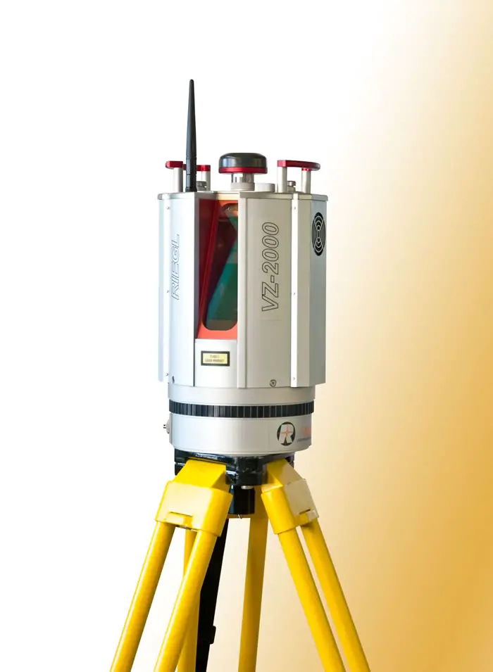
For terrestrial use the VZ scanner family provides a rapid and efficient way to collect highly accurate scan data from a tripod. RIEGL’s sophisticated technique of echo digitization and online waveform processing offers multiple target detection for each single laser shot, thus achieving superior measurement capability even under adverse atmospheric conditions like bad visibility due to dust. The instrument types – offering long range measurements up to 6,000m – are equipped with GPS receiver, inclination sensors, and digital compass. With this additional sensor data the scandata can be semi-automatically georeferenced. Built-in or optional external cameras and advanced camera options complete the offered systems. The latest addition to the VZ scanner family, the VZ-2000 offers a specified measurement range of more than 2,000m and a laser pulse repetition rate of up to 1 MHz.
Measurement ambiguities – which normally occur at such high measurement rates and long ranges – are automatically resolved by using RIEGL’s unique Multiple-Time-Around (MTA) Processing. In accordance with software packages like RiSCAN PRO (RIEGL’s well-established software for efficient data acquisition and registration), RiSOLVE (RIEGL’s one-touch solution for 3D digital scene capture especially suited for accident investigation), and RiMINING (offering an opimized workflow for applications in open-pit mining) user-friendly solutions for a variety of surveying applications are offered.
For mobile surveying like terrestrial corridor mapping, such as highway or railway corridors, RIEGL offers a range of mobile scanning systems from the simple VMZ Hybrid Mobile Mapping System to the high-end VMX Mobile Mapping Systems. The VMX series are exceptionally well suited to collect assets along the track at street / railtrack level. Through the combination of high density pointclouds and 360 degree panoramic images, the VMX systems provide rich datasets to serve geographic information systems for the purpose of planning, administration and maintenance of infrastructure. With the VMX-450-RAIL, a special package optimized for rail track surveying, provides application-specific outcomes, like clearance analysis, clash detection with train passage simulations, or surface monitoring for tunnel analysis. With the VMZ Hybrid System RIEGL 3D Laser Scanners can be used for some selected mobile applications, thus providing a cost-effective solution for data acquisition, e.g. in open-cast mining. RIEGL’s current development, the new VMQ-450 Mobile Single Scanner System will fill the gap. The integrated VQ-450 scanner provides 360° measurement range, the scanner head can be adjusted to variable positions for proper data acquisition, and by optional integration of cameras image data can be simultaneously acquired.
For large scale or nationwide projects airborne laser scanning systems for medium and high flying altitudes are available. Scanner Engines, like the RIEGL VQ-480i are used for vegetation management of power lines, thus reducing the risk of wildfires caused by vegetation encroachment of the electrical transmission lines. For national landscape management and mapping purpose high altitude scanners like the scanner engine LMS-Q780 or fully-integrated turn-key solutions like the airborne mapping system LMS-Q1560 provide high point densities at operating flight altitudes up to 15,500 ft AGL. High altitudes generate wide swath widths, thus decreasing the number of flight stripes to cover a certain area, which brings down the operational costs of an aerial survey.
In the last years, the use of high-end unmanned airborne platforms for surveying applications has gained in importance. UAS- and RPAS-based laser scanning offers the possibility to acquire data in dangerous and/or hard to reach areas, while offering an excellent cost-to-benefit ratio for numerous applications, e.g. precision farming, forestry and mining. For these smaller scale projects, RIEGL offers the VUX-1 LiDAR sensor, an extremely lightweight survey-grade airborne scanner which can simply be integrated in unmanned platforms. With the VUX-1 integrated, the new RIEGL RiCOPTER, RIEGL’s remotely piloted airborne laser scanning system, is ready for professional surveying missions. The robust and reliable airborne scanner carrying platform offers a MTOM (Maximum Take-off Mass) of up to 25kg, a payload of up to 16kg, a maximum operating flight altitude up to 500ft, and a flight endurance (with maximum payload) of 30 minutes. The carbon firbre main frame, foldable propeller carrier arms, and shock-absorbing undercarriage enable stable flight, safe landings and handy transportation.
Contacts;
Silvia Zaiser
RIEGL Laser Measurement Systems GmbH