In 2015, The World Bank headed to Tanzania where it teamed up with Drone Adventures, Humanitarian OpenStreetMap and the Tanzanian Commission of Science and Technology (COSTECH) to conduct urban mapping projects using senseFly eBee drones.
In Dar es Salaam, Tanzania’s largest city, The World Bank (TWB) is working with government departments on a range of development projects. These include: transportation projects, flood mitigation schemes, and other preparedness and assessment projects.
A dearth of data
The challenge the organization faces on the ground is a lack of accurate, up-to-date geographic data of the city.
TWB’s team wants to improve its understanding and identification of flood risk areas, largely driven by the devastating effect floods can have on the city’s informal settlements.
The problem is that satellite imagery of the region is expensive and doesn’t offer full coverage. The cost of using a manned aircraft is also extremely high. This is why, in 2015, TWB decided to look into how drones could help – the idea being to use them to collect high-resolution geospatial data, cost effectively. Thus TWB turned to Drone Adventures, a non-profit group that uses senseFly eBee mapping drones, and the team at Humanitarian OpenStreetMap (HOSM).
Doing the double
The Dar es Salaam project involved two missions, one month apart. “The first trip to Daar es Salaam was mainly a feasibility analysis and preparation for the second mission, where the majority of the data collection was carried out,” says Adam Klaptocz, co-founder of Drone Adventures.
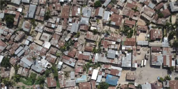
The project’s target ground resolution was highly precise, just 5 cm (2 in) per pixel. The area to map, says Klaptocz, was huge, “a large chunk of downtown Dar es Salaam— mostly informal communities made up of shelters and shacks”. The total mapping coverage: over 88 km2 (55 mi2).
The team flew two senseFly eBee drones during the first mission, and three during the second, managing these flights via the drones’ eMotion ground station software. Since landing zones were sparse in such a built-up urban environment, the team used a school yard as the project’s primary takeoff and landing location.
Managing the data
One of the biggest challenges was keeping track of the drone-collected data and the team’s image processing work.
“We flew multiple flights over several days in different conditions so that we could pack in as much data collection as possible during our trip,” Klaptocz explains. “The changing weather meant lots of differences in image lighting, so we needed to prune the data a little afterwards.”
Building consensus
TWB’s team liaised with each ward’s officer about the work taking place. They explained what was happening with the drones, what data was being collected and how outputs such as orthophotos and digital surface models would be used.
The local leaders were enthusiastic. “They liked the new technology, but aside from the cool factor they understood the potential impact of the data—they were aware of the need and value of up-to-date geospatial information,” Klaptocz says.
Real-world results
The dataset the mission produced was huge, detailed and is now proving of great value to many organizations and government departments. The dataset comprises ten orthophotos, produced by processing over 20,000 aerial images. This dataset was delivered to TWB, whose team used it to generate accurate 3D elevation models—used, in turn, to run flood simulations that help identify at-risk areas.
Here is what Edward Anderson of TWB, who was involved on the ground, said about the mission:
“The novelty value of the drones increased interest and participation in the project, and engaged our government clients. The main orthophoto the drone data produced is already being used for roof print digitization, and we’re planning to use the digital model for inundation mapping. I see drones as having great cross-sectoral potential.”