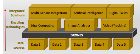
Drones are generally associated with extending the range and reach of remote sensing technologies. They, however, also play a role in enabling a more integrated, automated and predictive view of facilities and infrastructure.
Data in Construction Projects
Generally the BIM (Building Information Model) life-cycle of a construction project is a very popular framework for collecting and organizing information relating to building project.
Application of sensors on drones in construction
A spate of technological advancements have accelerated the application of sensors in construction.
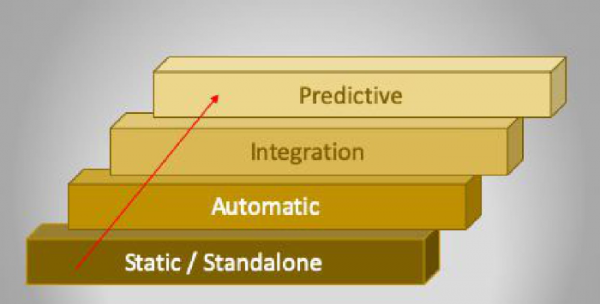
Automatic data collection and analysis provide immense opportunities to improve, automate and optimize construction processes of major infrastructure of facilities which is a major advance from relying on static and standalone data sources.
New and innovative approaches that foster the application of sensors and remote sensing technologies on construction projects are, hence, eminently desirable for the growth and development of the construction industry.
Some of these applications include:
- Construction features can be extracted from point clouds and images
- Remote sensor-based damage detection, and health monitoring of infrastructure projects;
- Automated sensor-based progress monitoring, modular fabrication verification, and on-site quality control;
- Artificial intelligence, machine learning, and deep learning for the analysis of field sensor data;
- Multi-sensor systems and data fusion in construction, including virtual and augmented reality (VR/AR);
- Radio frequency-based real-time location systems (RTLS) in construction.
Types of Data
There are various types of data that can be collected.
- High resolution color imagery are uised to identify silhoette /or outline of construction, damage to pipeline infrastructure and /or vegetation affecting pipeline infrastructure.
- Multispectral imagery can be used to identify monitoring line right of way, occupying and damaging vegetation as well as be used to assess condition of concrete surfaces.
- LiDAR can be used to create a 3D digital model. Due to the high accuracy of Lidar models you can make 3D models (digital twins) of pipeline and its relation to the first digital model of when the pipeline was installed to work out where the pipeline has shifted to after time and predict possible damage and modify pipeline to pre-empt damage that can occur.
- Thermal can be used to identify possible defects. Using general wave cameras using RGB imagery and thermal overlay you can predict weaknesses in pipes and possible leaks and send out inspection teams to measure if there is an actual leak or a bigger heat-shift reflecting structural failure.
- Methane Gas Laser Detection can be used for automatic detection of gas leaks on long line infrastructure (pipelines) without having to constantly monitor the display manually.
Methods
There are various smethods that can used combining the various sources of data mentioned earlier.
- Digital photogrammetry. This allows identifying faults in earth morphology through the analysis of chromatic variation of relief changes using specialized tolls and software. The result of this method is the KMZ file or geo-information file intended to control map data when identifying the location of detected changes. This method can be applied to monitor hydrocarbon pipelines laid above and underground.
- Spectrometric method. Two types of sensors are used to detect and identify hydrocarbon leaks in a liquid or gaseous state: multispectral and hyperspectral.
- Geothermal surveying method. Thermal imaging cameras make it possible to analyze tendencies of remote IR spectrum. It is also possible to identify hydrocarbon gases interacting with infrared spectrum
- Ground Penetrating Radar (GPR). GPR is a non-destructive geophysical method that uses radar pulses to image the subsurface. Through electromagnetic radiation in the microwave band (UHF/VHF frequencies) of the radio spectrum, GPR detects the reflected signals from subsurface structures and has application in scanning pavements and structures.
- Airborne LiDAR Surveys. Airborne LiDAR survey involves the use of a LIDAR sensor to rapidly scan the environment using Laser and GPS technology, saving on time and costs.
Emerging Technologies
Various emerging technologies have become available to enhance the data collection process.
Technology changes at a rapid pace and with the evolution of sensors on UAV platforms that can get closer to hard to access infrastructure, site managers have been able to digitize several aspects of their operations with a variety of recently emerging technologies.
- Artificial Intelligence. Using AI’s pattern recognition to detect that granular differences between different types of impacts and can detect with high confidence over the majority of the incidents,”
- Edge computing. Using several technologies like embedding of the sensor, storage, compute, advanced artificial intelligence, where intelligence will move towards the edgeof various endpoint devices installed in constructed infrastructure. These technologies connected through 5G networks, along with technologies such as IoT, cloud computing, and robotics are digitally transforming the industry.
- Drones, capable of integrating various payloads, sensors, and imaging technologies, effectively carry out operations like detecting adverse events, such as methane gas leaks, as well as corridor mapping, emergency response, and recovery, etc.
- Intelligent video surveillance systems. CCTV cameras when integrated with AI enable more advanced solutions like face recognition, object recognition, event recognition, intelligent image processing, remote asset management, behavioural detection, and analytics.
- Image analytics. AI allows the use of image analytics to monitor any deformation from the baseline profile of infrastructure. The real-time visibility of infrastructure integrity ensures safe operations, while also reducing the cost and human errors in meter reading.
Integrated Solutions
The real benefit comes with being able to integrate the various solution processes.
Major techniques include:
- Multi-sensor Data Integration that allows modelling of vital equipment such as flowmeters and valves using AI, as well as ensuring that detection is validated with more than one type of data. For example, in an oil pipeline, you would want to analyze the flow and improve corrosion, as well as identify and pinpoint potential leaks.
- By utilizing both AI and Edge Computing detect and alert central operations to potential issues such as leaks, corrosion, freezing damage or vandalism. It also allows operators to capture and analyze remote operations through image analytics. But above all it adds intelligence by predicting and optimizing infrastructure maintenance and integrity.
- A Digital Twin of a physical plant or asset can be used to optimize various processes before implementation on the physical asset and also make adjustments to facility designs. Different sensor types and devices may be integrated with the software to build digital profiles, and then used to predict and optimize infrastructure maintenance and integrity. Digital Twins
a. A digital twin represents the culmination of all the other digitalization efforts, combining the benefits of these efforts into one single 3600 experience and source of information for all stakeholders from engineering to finance and marketing.
b. By combining available operational data from existing systems, along with Multi- Sensor Data integration insights can be can be generated via an AI engine that predict asset failures and improve processes safely.
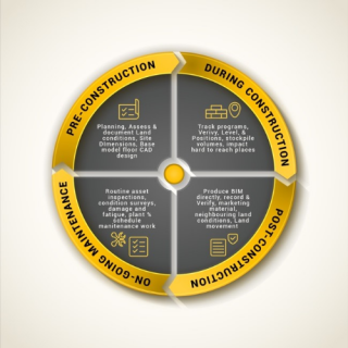
Monitoring Outputs Using Drones
Construction by its nature can be difficult to access and dangerous. Remote site surveys from an aerial perspective provides invaluable information in any construction project. The following output deliverables are common:
Aerial Site Assessments
Aerial drones are perfect for surveying large areas of developed land, construction sites and other high risk infrastructure.
Infrastructure Condition Assessment
The low-flying capabilities of drones ensure the capture of precise and detailed data, thereby providing up-to-date and accurate information to support business endeavours such as site development and building refurbishment.
Construction Progress Monitoring
Having photos of various stages of a construction project can show the progress of the project as well as assist in planning activities. The generated maps highlight the location of structures, foundations, and services such as piping, plumbing and electrical systems.
Survey and Mapping
Using photogrammetry (a surveying and mapping technique), drones provide quick deployment and turn-around times with accurate reporting from point cloud datasets. Reports include survey ground control, processing, and reporting tasks.
Topographic Surveys
Uneven terrain can cause difficult and hazard working conditions for surveyors travelling over land on foot. Drones are able to quickly and precisely retrieve topographical maps of large areas with minimal wear and tear on equipment and low risk.
As-Built Surveys
Accurate and detailed as-built drawings are essential to ensure the most current version of construction projects. Drones can survey areas of interest to offer superior, speedy, and accurate data and models in the cost-effective manner.
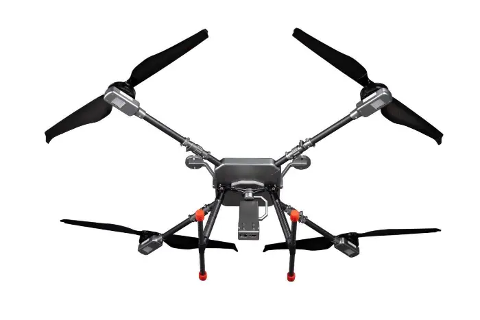
UAV Platforms
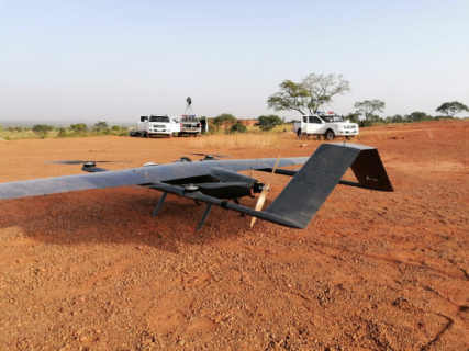
Different UAV (Drone) platforms are available to be deployed depending on the requirements.
- Quadcopters (or Multirotors) which make it possible to obtain maximum details for medium and small areas to ensure detailed scanning of subsurface pipelines.
2. Fixed wings can meet larger area monitoring requirements but provide lesser resolution and detail. A further refinement of UAV options is a VTOL (Vertical Takeoff and Landing) Fixed Wing that combines the strengths of both fixed wing and multirotor UAVs.
Drones are playing a key role in bring 4IR technologies to Construction projects.
Airborne Drones Is a specialist manufacturer of long range drones.