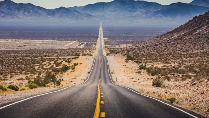
The world’s longest road is the 30,000-kilometre Pan-American Highway.
The highway cuts across the Americas, starting from Prudhoe Bay, Alaska, in North America, to Tierra del Fuego, an archipelago at South America’s southernmost tip, shared by Chile and Argentina. It traverses about 18 countries and links almost all of the Pacific coastal countries of the Americas.
Conception and construction of the Pan-American Highway
The idea of an overland route connecting the Americas was originally proposed as a railroad back in 1884 when the U.S. Congress passed a law with a plan to build an inter-American rail system.
This idea was discussed at the First Pan-American Conference 5 years later in 1889, however, the construction never started. The idea was later abandoned in 1903.
In 1923, the concept of building a highway, rather than a railroad, emerged at the Fifth International Conference of American States. At this time the automobile and other vehicles had begun to replace railroads for both passenger and goods transportation.
The first conference regarding the construction of the highway was held in October 1925. Finally, in late July 1937, a Convention on the Pan-American Highway was signed between Argentina, Bolivia, Chile, Colombia, Costa Rica, El Salvador, Guatemala, Honduras, Mexico, Nicaragua, Panama, Peru, Canada, and the United States.
These countries agreed to achieve speedy construction of the Pan-American Highway, by all adequate means.
Pan-American Highway route
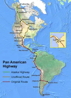
Moving from north to south, the Pan-American Highway route starts at Deadhorse, Alaska near the Prudhoe Bay oilfields. For the first 662 kilometers, the route follows the Dalton Highway to Fairbanks. From here there is a 155-kilometre section that culminates at Delta Junction. The junction is at the northern end of the Alaska Highway.
The route follows the Alaska Highway to Dawson Creek, B.C. from where it continues to Edmonton in Alberta. From Alberta, there are two possible routes, one of which goes through Minneapolis. It then follows Interstate 35 through Dallas/Fort Worth to the Mexican border at Laredo, Texas.
The second route runs through Calgary, Alberta and Billings, Montana, connecting with Interstate 25 through Denver, Colorado to Las Cruces, New Mexico. From there it continues through Interstate 10 to San Antonio, Texas, where it joins the first route.
Also Read: Top 5 longest roads in the world
The Mexican city of Nuevo Laredo, just across the border from Laredo, Texas, marks the start of the official section of the Pan-American Highway. From there the route runs to Mexico City along Mexican Federal Highway 45 and on to the border with Guatemala along Mexican Federal Highway 190.
It then proceeds through Central America, cutting across Guatemala, El Salvador, Honduras, Nicaragua, Costa Rica, and Panama. With the exception of Honduras, the route takes the Pan-American Highway through the capital cities of each of these countries.
The route through Central America terminates abruptly at Yaviza.
Pan-American Highway route from the Darién Gap
From Yaviza, the Pan-American Highway route resumes on the other side at Turbo, Colombia, in South America. It runs through Medellin and Cali before crossing the border into Ecuador at Tulcán.
In Ecuador, the road passes through Quito to Peru, where it follows Peru Highway 1. The latter runs the length of the country and connects all major cities in the coastal area, including the capital, Lima. On crossing from Peru into Chile the highway enters the Atacama Desert following Chile Route 5 through Antofagasta to Valparaiso.
From Valparaiso, the route runs to the Chilean coast on Route 5 terminating in Quellón on Chiloé Island. Another route heads east from Valparaiso following Chile Route 60 across the Andes Mountains to Argentina, where it becomes Argentina National Route 7. It then crosses the Pampas to Buenos Aires.
The final leg of the Pan-American Highway runs for 3,045 kilometers from Buenos Aires on Argentina National Route 3 to Ushuaia. It passes through Bahía Blanca and Comodoro Rivadavia. Near its southern end, the route proceeds to Chile crossing the Straits of Magellan to Argentina and on to Ushuaia on Isla Grande de Tierra del Fuego.
Can you drive the entire Pan-American Highway?
The entire Pan-American Highway route is motorable except for the Darién Gap. The approximately 106 km section from Turbo, Colombia to Yaviza, Panama was not constructed. Reportedly, this was because the swamps, marshes, and rivers, in this section would have made the construction cost very expensive at the time.
Efforts have been made for decades to eliminate the Darién Gap. Plans began back in 1971 with the help of United States funding. However, the plan was halted in 1974 after concerns raised by environmentalists.
Another effort to construct this section of the road began in 1992. By 1994 a United Nations agency reported that the road, and the subsequent development, would cause extensive environmental damage. The Embera-Wounaan and Kuna have also expressed concern that the development of this section of the road could bring erosion of their cultures.
Leave a Reply