Initio Earth Sciences also known as Initio Africa is a firm of professional surveyors. The firm was established in 1989 in South Africa principally to develop business throughout the African continent. In the years since the establishment of the company, our goals have remained constant, moreover the firm is pledged to:
• Perform professional services to an international standard
• Provide our clients with the most cost-effective solutions
• Be innovative
• Transfer technology and train our staff in every host country
• Keep abreast of changes in our profession
Since the inception of the firm, numerous projects have been completed throughout Africa. Their professionals regularly attend continuing education courses throughout the world.
The firm grew out of a need to provide professional services that would satisfy multinational institutes, lenders and developers while maximising local resources. This has allowed them to compete at a local level.
Aerial Surveying
Initio Earth Sciences offers cost effective solutions for all your surveying, mapping and modelling needs in the form of UAVs. Using small UAVs which are portable, dramatically reduces the time taken for traditional survey methods while still maintaining a high degree of accuracy.
Their equipment can generate a broad range of data types, including:
Orthoimages
Digital Terrain Model (DTM)
Digital Surface Model (DSM)
Volume Calculations
Contour and Topographic mapping
Point cloud generation
3D Visualization
FLIR Thermal Inspections
Pylon and bridge inspections etc.
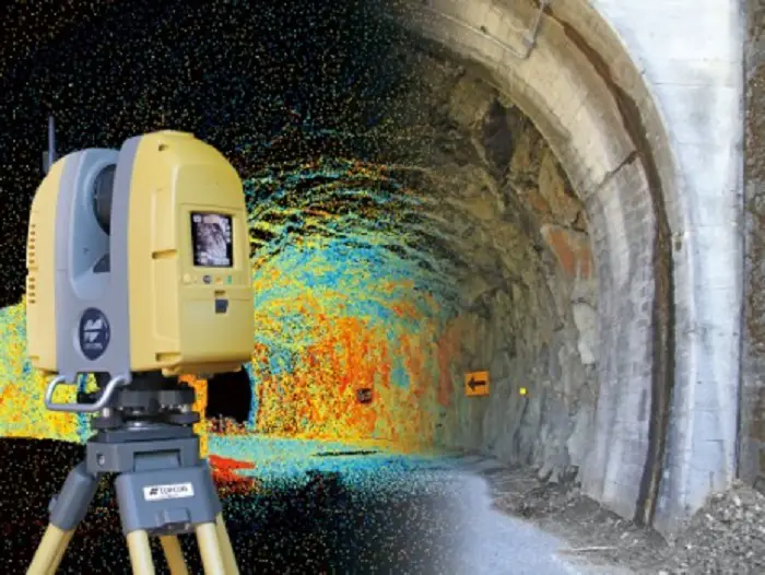
3D Laser Scanning
3D laser scanners enable us to capture data quickly and safely with immense detail and accuracy. Laser Scanning is becoming the preferred method of Mass Data collection for rapid inspection and as-built documentation for Architecture, Mining, Engineering and Reverse Engineering Applications.
The use of 3D laser scanning technology, provides us with detailed point clouds which enable 3D modelling with faster turnaround times on scans of buildings, plants, stockpiles, etc. Because laser scanning is a non-contact technology, it therefore provides increased safety in most working environments, making it a preferred means of data collection.
Land Survey
Initio Earth Sciences has been providing land, mine and engineering survey services throughout Africa for over 30 years.
Whatever phase (Design, Construction, As-Built) your project is in, they have the staff equipped to tailor to your needs.
At Initio Earth Sciences they make it a priority to evolve and stay abreast with the latest technology and software ensuring that they can work smart, fast and accurately.
Services they offer:
Topographic Surveys
Railway Surveys
Contour Plans
Volumetric Survey
Construction Surveys etc.
3D Modelling: BIM
At Initio Earth Sciences, they provide building information modelling services (BIM) from point cloud data. BIM models include all current building elements, such as beams, columns, and internal walls, ducting, among others.
Not only does it provide a digital representation of a building project, it also facilitates greater levels of collaboration and inter-operability within the design environment.
Not limited to buildings, they also model plant facilities with elements such as pipes, valves, flanges, beams etc. Models can be drawn in multiple design suites including Revit, Autocad etc.The output is dependent on the clients needs.
