Geospatial products distributor Aciel Geomatics has officially locally launched the Leica BLK360 imaging laser scanner – the world’s smallest and lightest image laser scanner.
Aciel Geomatics, the appointed distributor for Switzerland-based Leica Geosystems, launched the scanner at the geomatics industry’s yearly conference, the Geomatics Indaba, in Durban, KwaZulu-Natal, in August.
Also read:Xodus wins two ESIA contracts in Senegal
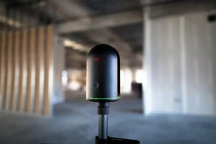
The Leica BLK360 imaging laser scanner can be used by architecture, engineering and construction professionals in applications such as building construction, renovations and retrofitting, shop refurbishments, forensic scene documentation, design and as-built valua- tions, Aciel Geomatics sales representative Barend Bornman noting that the scanner is able to capture a digital three-dimensional (3D) model representation of virtually any subject in images and point cloud form.
The scanner weighs 1.1 kg and is 165 mm high and 100 mm in diameter. It can operate in temperatures from 5 ºC to more than 40 ºC. Making it suitable for indoor and outdoor use. The scanner has a range precision of more than 4 mm at 15 m. Its range extends to 60m.
Also read: Symbion Energy signs a US$100m agreement for Rwanda’s methane gas generated power
About Leica
Leica Geosystems is about creating complete solutions from one source across leading brands. Also professionals worldwide trust Leica Geosystems solutions to help them capture, analyse and present spatial information.
Revolutionising the world of measurement and survey for nearly 200 years. Leica Geosystems is the industry leader in measurement and information technologies. They create complete solutions for professionals across the planet. Known for innovative product and solution development, professionals. In a diverse mix of industries, such as surveying and engineering. Building and heavy construction, safety and security, and power and plant trust Leica Geosystems for all their geospatial needs.
With precise and accurate instruments, sophisticated software, and trusted services. Leica Geosystems delivers value every day to those shaping the future of their world.
Additionally, Leica Geosystems is part of Hexagon (Nasdaq Stockholm: HEXA B, hexagon.com), a leading global provider of information technology solutions that drive productivity and quality across geospatial and industrial landscapes.
