The integration of openBIM® and GIS significantly improves urban and regional planning by combining detailed BIM models with advanced spatial data analysis and visualization.
These technologies are transforming urban management in cities, enhancing the efficiency and sustainability of planning and infrastructure management.
Discover the key aspects of this integration through the case study of Barcelona city and the geospatial digital twin technology usBIM.geotwin.
Understanding openBIM® and GIS
openBIM® is a collaborative approach for designing and managing construction information, based on open standards to facilitate interoperability among various stakeholders and software applications. This method enhances communication and data sharing throughout the project lifecycle, leading to more efficient project execution.
GIS (Geographic Information System) is a framework for gathering, managing, and analysing spatial and geographic data. It plays a crucial role in urban and regional planning by providing tools for spatial data analysis and visualization, which are essential for informed decision-making.
The integration of openBIM® and GIS
Integrating openBIM® and GIS allows combining the detailed information from BIM models with the spatial context and analysis capabilities of GIS.
It provides a lot of functionalities as the following:
- visualizing BIM data in a geographic context for better decision making;
- analysing site conditions and impact on the project;
- simulating and modelling the built environment and its interactions;
- enabling digital twins that combine BIM and GIS for the entire lifecycle.
The integration requires careful planning and training, but provides a powerful platform for designing, constructing and operating buildings and infrastructure.
Leading solutions like usBIM.geotwin from ACCA software and Esri enable intelligent integration of IFC openBIM® models and processes (ACCA software’s BIM management system usBIM) with maps, scenes and GIS functions (Esri’s ArcGIS®) for creating and managing geospatial digital twin of the project without any dimensional limitations.
openBIM® models on GIS maps: usBIM.geotwin
Benefits of the openBIM®-GIS integration
The integration of openBIM® and GIS offers a multitude of benefits that enhance project management, design efficiency, and overall effectiveness in the architecture, engineering, and construction (AEC) sectors.
Here are the key advantages:
- enhanced collaboration and communication: the integration fosters better collaboration among project team members by providing a unified platform for sharing information, which helps to minimize errors and enhances project quality;
- improved project planning and design: combining openBIM® with GIS allows designers to visualize project data within a geographic context, aiding in understanding environmental factors and site topography, which leads to more informed design decisions;
- streamlined information processing: the integration significantly reduces the time and effort required for data processing;
- better resource management: it enhances resource management by optimizing material transport routes and assessing environmental impacts, thus improving project sustainability;
- increased accuracy and safety: the use of integrated openBIM® and GIS models improves construction accuracy, reducing the likelihood of errors and enhancing project quality;
- long-term asset management: integrated openBIM® and GIS models are valuable for managing assets throughout their lifecycle, allowing for data reuse and informed decision-making in facility management;
- cost savings: by eliminating redundant data and improving design efficiency, the integration can lead to significant cost reductions throughout the project lifecycle.
The case study of Barcelona
The integration of openBIM® and GIS in urban planning and management is exemplified by the case study of Barcelona.
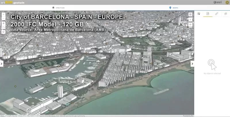
Through the use of the geospatial digital twin software usBIM.geotwin, 2,000 IFC models were seamlessly integrated, amounting to 120 GB of data. This demonstrates the system’s capability to handle complex and large-scale datasets without limitations on data volume or update frequency.
The incorporation of a diverse array of openBIM IFC models within the digital smart city enables efficient and intelligent management of various urban services and systems.
Federation of 2,000 IFC models in GIS environment: the case study of Barcelona city
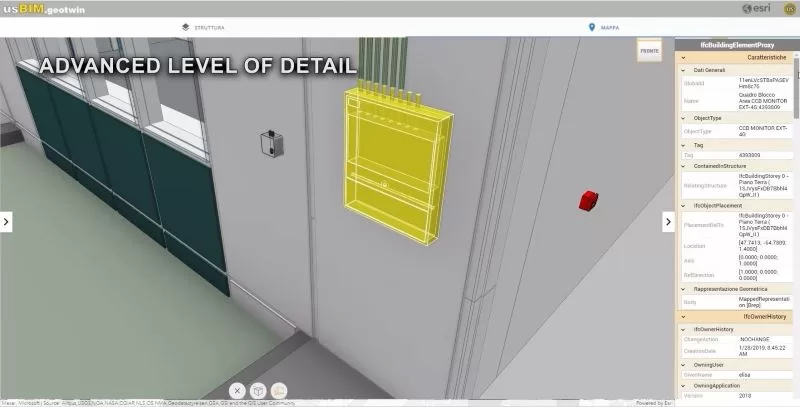
From the geospatial perspective, users can conduct advanced spatial queries and delve into a high level of detail to examine the attributes of each building and infrastructure at architectural, structural, and MEP levels. This capability facilitates an in-depth analysis of resources within the surrounding environment.
Advanced level of detail: usBIM.geotwin in urban environment
This integration not only enhances the visualization and management of building installations, but also significantly improves the efficiency, safety, and sustainability of urban infrastructures.
usBIM.geotwin software empowers users to a series of activities such as the below:
- monitoring real-time building performance;
- optimizing maintenance operations;
- anticipating potential issues, thus fostering a more proactive and intelligent approach to urban management.
Watch the video to learn more:
Leave a Reply