How an understanding of Geology and Geotechnics can aid Structural Design report by Oliver Woodruff (CEng MICE).
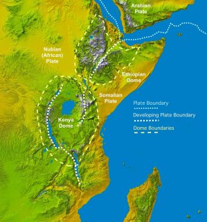
Uganda, a land of rich geological history, sits upon the African Techtronic Plate which encompasses the majority of continental Africa. However in recent geological history, it has begun splitting in two, with the Nubian Plate; making up most of mainland Africa, and the Somalian Plate to the East, diverging from the Arabian Plate to the North.
Elevated heating from the Earths’ Mantle has, over time, sent up heat flumes that have created two large thermal bulges under the Crust beneath Kenya and Ethiopia. These bulges can readily be seen in the elevated highlands that extend from the source of the divergence in North-Eastern Ethiopia down into Central Kenya.
As these plumes rise, the overlaying crust is heated and expands, however just like heated metal, once it cools it becomes brittle and cracks as it tries to contract, creating typical ‘horst and graden’ structures that are symbolic of rift valleys.
Traditionally in the creation of rift valleys through thermal expansion, the cracking occurs at a source point and the associated geological structural features radiate out at an angle of approximately 120 degrees. The East African Rift System is no exception.
In the Afar region of Ethiopia and Djibouti (see figure 2) it is possible to physically see the start of this process. This location is the central source of the radiating rifts – or ‘triple-junction’ – and to the south follows the Southern East African Rift Valley.
Uganda’s Geological Make-up
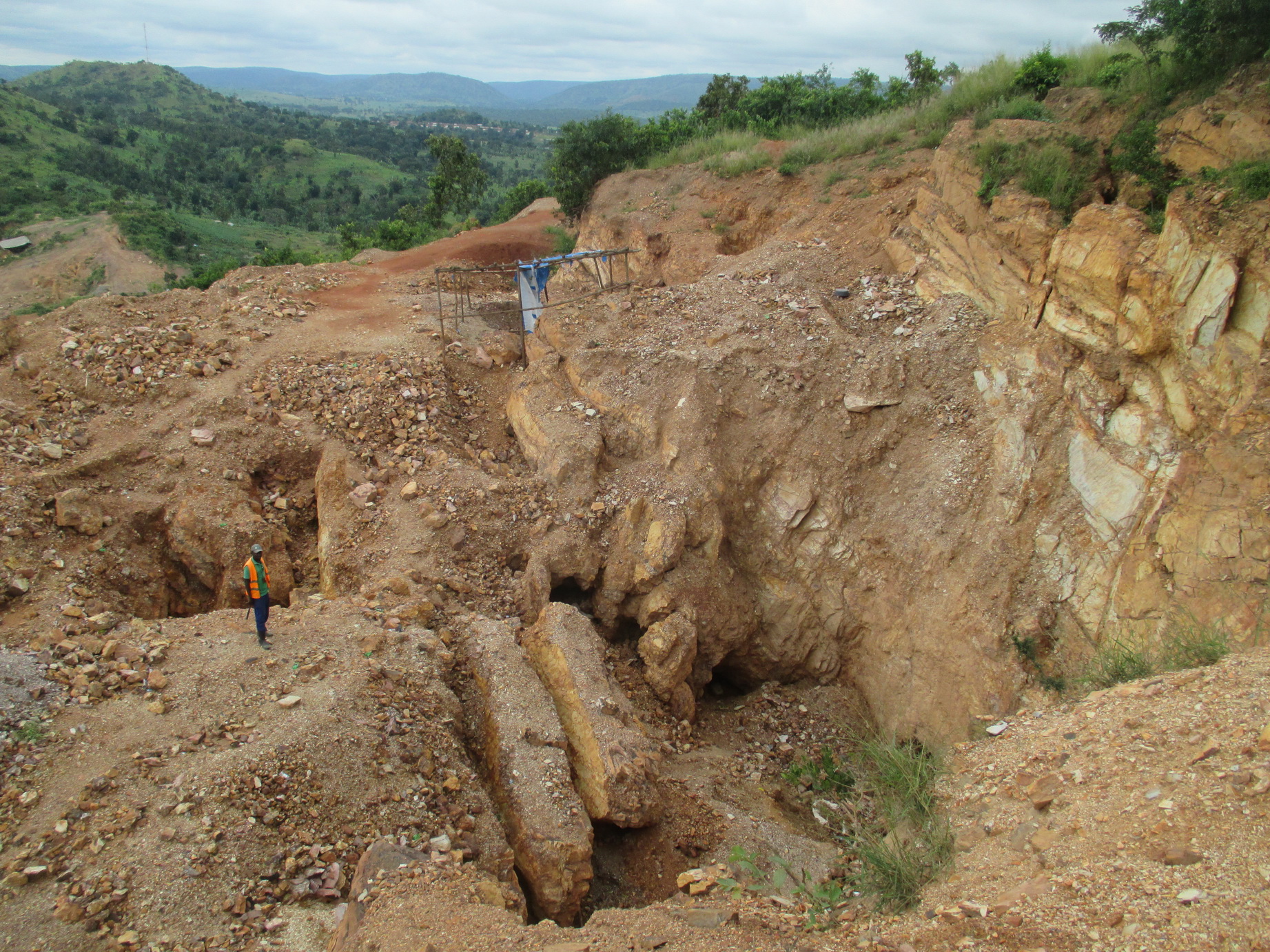
Underlying much of Uganda sits a basement complex of rock that is generally referred to as an extension of the ‘Tanzanian Shield’ – a Precambrian crystalline cap comprised of rocks from the Archaean and Proterozoic geological timeline, with a varied mix of lithology – rock types.
The Shield, or craton, in Uganda is generally of sedimentary origin formed of very hard granites and gneisses that were created between 2700 – 2500 million years ago (Ma) under high levels of metamorphism.
The East African Rift started traveling South from Ethiopia, however as it approached the modern-day border with Kenya and Uganda, the old and stable craton protected this region, and due to its geological makeup, deflected the cracking around its edges.
To the East, the rift continued south, splitting Kenya in two, while in the West, the Lake Albert or Albertine Rift was created. This element of the fault ran along the north of Uganda before turning south, following the Ugandan-Congo border and creating the Great Lakes found within this region; including Lake Tanganyika, the World’s second deepest freshwater lake.
Lake Victoria, the catchment point of this region and source of the White Nile, sits in the low point between these two Rifts above this large area of ancient metamorphic rock. Around 2500 million years ago, during the Achaean-Proterozoic switchover, three systems of geological activity have been identified with different levels of intensity and are responsible for the varied rocks found throughout the country.
Figure 2; Afar Triple Junction
Buganda-Toro – The Buganda-Toro or Paleo-Proterozoic system was formed between 2500 Ma and 1800 Ma and is found in the South West of Uganda. Starting along the shore of Lake Victoria, this band of rock stretches across the Central South into the core of the Rwenzori Mountain chain at the Congolese border. This rock is a compound of non-calcareous sedimentary rocks typical of the higher levels of metamorphism that is synonymous with this time period. Typical rock types include quartzes, schist’s and gneisses, while this system is responsible for a host of gold, copper and cobalt ores found in this band.
Karagwe-Ankolean – The Meso-Proterozoic system is located mainly in Southwest Uganda on the triple border with Rwanda and Congo and extending well into the latter and was established 1600 – 1300 Ma. The system is part of the Kibaran Fold Belt – responsible for mountain building in this region – and although it contains rocks that are similar to the earlier Buganda-Toro system, they are less metamorphosed and typical shallow-water sediments with shale, sandstones and, within the centre of anticlines, intrusive granites, among the most predominant examples.
Bukoban & Karasuk – Thought to straddle the Neo-Proterozoic and Paleozoic (Cambrian) boundary between 1000 and 550 Ma, this last Proterozoic system is formed of rocks that have very little metamorphism or deformation; typically mudstones, sandstones, and limestone. However, the geology from this period was overprinted with the igneous mountain building during the Mozambique orogenesis 630 Ma. As a result, in northern and eastern parts of the country there can be found lava flows, gneisses and marbles.
The end of the Precambrian geological time period was to herald the start of the period were Uganda was affected and shaped by volcanic and orogenic activity. Starting with the aforementioned Mozambique orogenesis, and continuing through the Upper Carboniferous (~300 Ma) and Upper Jurassic (~150 Ma) through to the Cretaceous (90 Ma), Miocene (30 Ma) and throughout the Cerenozic, the events created small pockets of varied geology along the eastern and western boundaries of the country.
Following the Kenyan border, the volcanoes to the east are older than their cousins to the west. They were created around 50 Ma, and during their history have been eroded to nearly half their initial height, spreading and depositing their volcanic remnants over several parts of this region that can often be found as bold limestone outcrops.
(Sipi Fall’s near Mbale for instance) On the other hand, the creations of the Western volcanoes, some of which within the Congo are still very much active, are confined to the later Pleistocene (0.150 Ma). The sediments 3 and volcanic rocks from these now cover the western rift valley, often to a depth of 4,000m.
Kampalan Geology in Structural Design
While it is useful and interesting to be aware of the creation of a landscape, for engineers the main interest in geology, is often confined to a single plot within a small to medium town or city.
Therefore during the desk study for any construction project, the soil properties within the upper portion of the Earth’s crust are what is sought and collected through a combination of reference research and, often due to the limit in geotechnical information available; new intrusive surveys. The initial geotechnical markers during this period of the project are typically threefold;
Soil Type & Sequencing; Soil is any material that is formed from a combination of weathered rock particles that are connected in some way and contain air-filled void spaces and are typically found in layers or sequences.
This weathering may be as the result of glaciation, numerous forms of erosion or through the freezing and thawing effect. When these eroded particles combine with others of the same or different parent rocks, they are connected to form loose, medium or dense structures depending on the method of weathering, deposition and compaction of the particles which vary in their characteristics and suitability in construction.
In Kampala, the typical soil type is a layer of clay-like soil overlaying a deeper build-up of silts that sit upon the hard bedrock. The silts are vicarious in nature and were laid down during the period where Lake Victoria’s shores extended further than they do today.
As with any lakebed sediments, the material was deposited over millennia to form fine-grained layers of silt. The overlying clay, on the other hand, is a laterite soil (commonly referred to as Murram in East Africa) rich in iron, hence the deep red color, and aluminium, and created from the leaching of the parent rock via an acidic weathering. This is brought on due to the cyclical wet and dry seasons found between the tropical latitudes.
Bearing Capacity; each soil type has an individual structure that gives it a characteristic strength and allows it to resist a vertical axial load placed upon it. The magnitude of this load is determined by the soil type.
The allowable bearing capacity of a soil is the calculated factor of strength of that soil in kN/m2, and as long as the building foundations do not exceed this value they will ignoring other factors, be able to suitably distribute their vertical load into the ground without the ground failing beneath them.
The allowable bearing capacity is defined as ‘the maximum pressure which may be applied to the soil such that the foundation, and the operations involved in its construction, should have no adverse effect on adjacent structures and services.’ 2 Kampala, as described previously, has a fairly typical soil type makeup and therefore when an engineer looks at the average values of allowable bearing capacity as compiled from intrusive surveys across the city, they will be able to see a general pattern in the results.
Generally, in the plots surrounding Lake Victoria, the deeper we go the higher the bearing strength of the soil. Now 2 R. F. Craig, Soil Mechanics, Fourth Edition, Chapter 8, Chapman and Hall, London 4 this is fairly typical of anywhere in the World, however because we know of the micaceous soil that lies in the region, at 5-15m below the surface this isn’t always as clear cut as the numbers portray.
Due to the nature of this soil, which as we have described is a densely compacted sedimentary material, if it is exposed to water, it will liquefy rapidly and the measured strength will become obsolete to the engineer.
The top layer must then be removed to find the undisturbed dry layer. More often than not this isn’t discovered until excavations start on site, especially during the rainy months of the wet seasons.
Another reason could be due to the rise of the groundwater through ground heave from the removal of the overlying soil. If this is the case, the Engineer’s calculations could be inadequate. Therefore it is crucial the level and fluctuations of the water table are established and monitored.
Water Table; often during excavations for foundations, the water table can be close to the base of the foundation. Therefore during intense periods of rain, like those experienced in the wet seasons on Kampala, the water table will undoubtedly rise and can potentially enter the excavations.
As we have discussed, although this in itself might not be a problem, if the soil type does not react well with water, the allowable bearing capacity of the soil may reduce considerably.
Kampala is a city, like Rome, built on hills, and these steep hills alter the shape and profile of the water table as much as the heavy rains do. Aside from seasonal fluctuations, this groundwater profile can alter through a number of actions including; excavations, cut & fill processes and landslips, but typically will try and follow the boundary between the permeable and impermeable soil and rock layers.
In areas where old less permeable lake bed deposits exist however, this profile may be harder to determine and will instead depend on the level and depth of these deposits rather than the topography of the land.
Also common are perched water tables, where the aquifer sits above the main water table due to a layer or pocket of impermeable rock or sediment that occurs above or within the more permeable surrounding soil.
This form, which can be created accidentally during construction operations, can often be misleading to the results generated during a ground investigation. The numbers which show ‘groundwater’ at a higher level than might have been anticipated during the initial site survey could have an effect on the later design and construction and must, therefore, be closely inspected.
Concluding Remarks
Although the intrusive ground investigation can be seen as a ‘hidden’ cost and not necessarily generate any tangible products for the clients outlay, it is vital that the Engineer attempts to explain that the short term results may help with the initial design of a structure when it comes to determining the height, building usage, but also in potentially reducing the long term cost of construction.
Having a better and more detailed understanding of the ground beneath a structure will allow for a more efficient design with possibly reduced foundations and saving in materials. The ability to find any potential sources of future problems such as low bearing capacity at the design stage might allow the client to make an informed decision on whether to go ahead with the project, rather than be faced with greater construction cost mid-program due to hidden surprises.
Select Glossary
Craton – or Shield is an old and stable part of an ancient continental mantle, often found in the interior of the continent.
Orogenesis – in its simplest; mountain building
References;
- Simplified Geology of Uganda, the Mining Journal of Uganda Extract, April 1996
- East African Great Rift Valley; A Complex Rift System, James Wood and Alex Guth, Michigan Technological University
- Geological Overview of Uganda, Ugandan Department of Geology Survey and Mines
- Geological Map of Uganda (circa 1950)
- Soil Mechanics, R.F.Craig, Fourth Edition, Chapman & Hall, London.